


The beautiful coastal town of Santa Barbara, perched between Santa Ynez Mountains and the Pacific, is a perfect spot for a Mediterranean-inspired vacation with its architecture, vegetation, and coastline. Also called American Riviera, this location provides some of the best hiking experience in the nation. Its surrounding areas feature manicured gardens, canyons, creeks, wildflowers, rare plants, wildlife, and much more. It has several trails, traversing these natural wonders, and high elevations with heartwarming 360-degree views. Whether you are an experienced hiker looking for some challenging routes or traveling with family, this place has the right track for everyone. Check out these best hiking and trekking spots in Santa Barbara, California.
1. McMenemy Trail
Editor's Note: There's no photo available at the time of writing
Enjoy a recreational walk with awe-inspiring views along the moderately challenging McMenemy Trail that runs 5.5 miles (8.9 kilometers) from San Ysidro trailhead to Saddlerock or 3 miles (4.8 kilometers) to Girard trailhead. It is a loop-like trail that ascends to 1,000 feet (304.8 meters) along the hills perched behind Montecito, California. Hiking McMenemy Trail is a good form of exercise while being blessed with vistas of the surrounding flowers and plants, and you can also take your leashed dog along.
McMenemy Trail
Address: McMenemy Trail, Montecito, CA 93108, USA
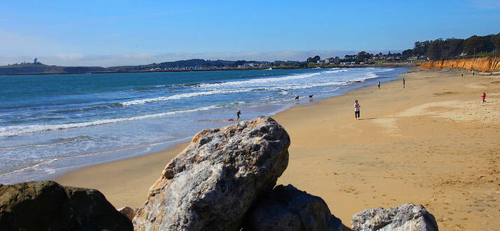
2. Arroyo Burro Beach Loop

This trail is on the beaten path for tourists and locals, and it’s almost always crowded for its several attractive features. Aside from being only 1.3 miles (2.1 kilometers) long, it highlights delightful views of wildflowers, dogs can be off the leash, and it’s suitable for all skill levels. Arroyo Burro Beach Loop traverses through Douglas Family Preserve, which used to house a nursery. Enjoy a scenic walk along the bridge connecting Mesa Creek and the bluffs. The coastal views from the top of the seaside cliffs are also irresistible.
Arroyo Burro Beach Loop
Address: 2981 Cliff Dr, Santa Barbara, CA 93109, USA
3. Lake Cachuma Sweetwater Trail

Enjoy a variety of activities, including camping, sightseeing, hiking, and fishing along Sweetwater Trail, which lies along the stretch of Lake Cachuma, Santa Barbara’s main water supply. It’s a less crowded track, which runs 4.5 miles (7.2 kilometers) from the southwest end of the recreational spot to Bradbury Dam Vista Point. The easy path passes through green meadows, wild places, and up and down short hills. There is a food spot at the end of the trail, swimming is not allowed, and dogs must be kept on leash.
Lake Cachuma Sweetwater Trail
Address: HC 59, Highway 154, Santa Barbara, CA 93105, USA
You might be interested in these Airbnbs!

4. Aliso Canyon Trail

Check out the most variety of spring flowers the city has to offer, as well as beautiful views of the river along Aliso Canyon Trail, which cuts through Los Padres National Forest. This path provides you with two options—a moderate 3.5-mile (5.6-kilometer) loop hike with marvelous views of Santa Ynez River, or an easy 1-mile (1.6-kilometer) walk along the shady Aliso Creek. You can also purchase descriptive material of the plant varieties, including fairy lanterns and Chinese houses, along the path at Los Prietos Ranger Station, which marks the start of this remarkable adventure.
Aliso Canyon Trail
Address: Los Padres National Forest, CA 93105, USA
5. Red Rocks to Gibraltar Dam Trail

Saunter amid red rock formations, besides many pools, and marvel at amazing views of the wilderness along this well-maintained route stretching 6.5 miles (10.5 kilometers). The hike starts from the area’s ample parking space, some 10 miles (16 kilometers) off Paradise Road, featuring a picnic table, trash bins, and vault toilets for your convenience. The track is situated within Los Padres National Forest, so it’s usually crowded. Leashed dogs are allowed, and the trail’s level of difficulty is moderate. Also, make sure to carry your own drinking water.
Red Rocks to Gibraltar Dam Trail
Address: Gibraltar Trail, Forest Rte 5N18, Santa Barbara, CA 93110, USA
6. San Antonio Creek Trail

This 2.9-mile (4.7-kilometer), mostly shaded trail provides a pleasurable hike, especially in spring, featuring canyon vegetation, oak woodland, and beautiful creeks with cascading cool water. It starts from Tucker’s Grove, a favorite weekend picnic spot, which has a kids’ playground. The easy hike has a total elevation of 300 feet (91.4 meters), and joggers and other fitness enthusiasts heavily use it. On a typical day, it is not too crowded, offering a peaceful and enjoyable experience.
San Antonio Creek Trail
Address: Tucker’s Grove, Santa Barbara, CA 93111, USA
Opening hours: 24 hours (daily)
7. Santa Cruz Island: Pelican Bay Trail
Editor's Note: There's no photo available at the time of writing
Discover a great variety of animals and plants exclusive to Channel Island on this 4.5-mile (7.2-kilometer) roundtrip walk along Pelican Bay Trail to Prisoners Harbor. Trailing this moderately difficult path with its delightful wooded areas will take you back to when the Chumash inhabited it. Enjoy the beautiful views of the unspoiled nature conservancy area along the route, with rare native plants and birds, as well as stunning views of more than five canyons.
Santa Cruz Island: Pelican Bay Trail
Address: Pelican Bay Trail, Santa Cruz Island, CA 93001, USA
8. Parma Park Trail

Parma Park, which covers an area of 200 acres (80.9 hectares), is the largest in the city and features open green space, five connected trails, chaparral, and a woodland. It is a popular landing spot for hang gliders and paragliders, as well as a perfect hiking and picnic area. Along the 5.5-mile (8.9-kilometer) path, Ridge Trail to Rowe’s Table is the most appealing, highlighting impressive vistas of Santa Barbara Channel Islands, Montecito, and the beautiful city. It is a moderately difficult route, and you can explore it with your leashed dog.
Parma Park Trail
Address: Stanwood Dr, Santa Barbara, CA 93108, USA
Opening hours: 24 hours (daily)
9. Stevens Park
Editor's Note: There's no photo available at the time of writing
Stevens Park is a 25-acre (10.1-hectare) recreational center perched at the entrance of Foothill Road Bridge in San Roque Canyon. It is a lovely spot to hang out with family, featuring barbecue sites, shaded picnic areas, a swimming pool, a large kids’ playground, a hiking trail, and much more. The track is a natural 1.6-mile (2.6-kilometer) roundtrip hike to Jesusita Trail. Along this path, you will see beautiful flowering meadows, oak trees, sycamore trees, and much more. Your toddler will find this route pleasant, and you can even take your leashed dog along.
Stevens Park
Address: 258 Canon Dr, Santa Barbara, CA 93105, USA
Opening hours: 8am - 6pm (daily)
10. Rattlesnake Canyon Trail to Tunnel Trail

Enjoy a relaxed and refreshing stroll down this path, which lies only 15 minutes from downtown by car. Mind you, the name “rattlesnake” doesn’t mean that the trail is full of snakes. Instead, you will discover many deep pools, glamorous waterfalls, and the wilderness along its shady route. The first part of the hike stretches 2.5 miles (4 kilometers) to the connector trail, which is well-maintained. The second part of the path, which is 0.6 miles (1 kilometer) long, starts from the connector trail and proceeds to Tunnel Trail. If you are going with kids, also check out Skofield Park, which is adjacent to Rattlesnake Canyon Trail.
Rattlesnake Canyon Trail to Tunnel Trail
Address: Las Canoas Rd, Santa Barbara, CA 93105, USA
Enjoy the best hiking experience
Santa Barbara is a haven for hikers, as it features a perfect mix of fun, recreation, and challenging loops. With these best hiking and trekking spots in Santa Barbara, you are only a trip away from a thrilling outdoor experience. Do note that there are areas, especially Los Padres National Forest, that will require you to buy an adventure pass.
History
Get Trip101 in your inbox
Unsubscribe in one click. See our Privacy Policy for more information on how we use your data


Create an account to