Destinations
North & Central America
Countries
USA
Canada
Mexico
Puerto Rico
Dominican Republic
Popular Destinations
Alaska
Anchorage
Austin
Bermuda
Boston
Calgary
California
Cancun
Cayman Islands
Chicago
View all Destinations in North & Central America
South America
Countries
Brazil
Argentina
Colombia
Peru
Chile
Popular Destinations
Bogota
Lima
Rio de Janeiro
Santiago
View all Destinations in South America
Europe
Countries
UK
Italy
France
Spain
Germany
Popular Destinations
Amalfi
Athens
Berlin
Budapest
Dublin
Dubrovnik
Lisbon
London
Amsterdam
Barcelona
View all Destinations in Europe
Asia
Countries
India
Pakistan
Philippines
Japan
Thailand
Popular Destinations
Bali
Bangkok
Beijing
New Delhi
Goa
Ho Chi Minh City
Hong Kong
Kyoto
Seoul
Shanghai
View all Destinations in Asia
Africa
Countries
South Africa
Egypt
Kenya
Morocco
Tanzania
Popular Destinations
Botswana
Cairo
Cape Town
Johannesburg
Marrakech
Mauritius
Nairobi
Zanzibar
View all Destinations in Africa
Middle East
Countries
United Arab Emirates
Israel
Qatar
Lebanon
Popular Destinations
Abu Dhabi
Amman
Doha
Dubai
Istanbul
View all Destinations in Middle East
Oceania
Countries
Australia
New Zealand
Fiji
Guam
French Polynesia
Popular Destinations
Auckland
Brisbane
Hobart
Melbourne
Perth
Sydney
Tahiti
Tasmania
View all Destinations in Oceania
All Destinations
Countries
USA
Canada
Mexico
Puerto Rico
Dominican Republic
Popular Destinations
Alaska
Anchorage
Austin
Bermuda
Boston
Calgary
California
Cancun
Cayman Islands
Chicago
View all Destinations in North & Central America
Countries
Brazil
Argentina
Colombia
Peru
Chile
Popular Destinations
Bogota
Lima
Rio de Janeiro
Santiago
View all Destinations in South America
Countries
UK
Italy
France
Spain
Germany
Popular Destinations
Amalfi
Athens
Berlin
Budapest
Dublin
Dubrovnik
Lisbon
London
Amsterdam
Barcelona
View all Destinations in Europe
Countries
India
Pakistan
Philippines
Japan
Thailand
Popular Destinations
Bali
Bangkok
Beijing
New Delhi
Goa
Ho Chi Minh City
Hong Kong
Kyoto
Seoul
Shanghai
View all Destinations in Asia
Countries
South Africa
Egypt
Kenya
Morocco
Tanzania
Popular Destinations
Botswana
Cairo
Cape Town
Johannesburg
Marrakech
Mauritius
Nairobi
Zanzibar
View all Destinations in Africa
Countries
United Arab Emirates
Israel
Qatar
Lebanon
Popular Destinations
Abu Dhabi
Amman
Doha
Dubai
Istanbul
View all Destinations in Middle East
Countries
Australia
New Zealand
Fiji
Guam
French Polynesia
Popular Destinations
Auckland
Brisbane
Hobart
Melbourne
Perth
Sydney
Tahiti
Tasmania
View all Destinations in Oceania
Airbnb & Vacation Rentals
View all Vacation Rentals
Airbnb
Vrbo
Bookabach
Stayz
Vacasa
Glamping
Camping
Vacation Rentals
Yurts
Airbnb Mansion
Villa Rental
Pet Friendly Cabins
Cabins With Hot Tubs
Secluded Cabins
Vacation Rentals With Private Pool
Lakefront Rentals
Pet Friendly Airbnb
Airbnb Monthly
Cheap Airbnbs
Luxury Airbnb
Airbnb Hot Tubs
Hotels & Resorts
View all Hotels
Resorts
Motels
Homestay
Hotels With Hot Tubs
Hotels With Pools
Luxury Hotels
Boutique Hotels
Hotels With Kitchen
Cheap Hotels
Beachfront Hotels
Pet Friendly Hotels
Hotels With Water Parks
Hotels With Rooftop Pool
Hotels With Infinity Pool
Adults Only Hotels
2 Bedroom Hotels
Family Resorts
All Inclusive Resorts
Romantic Getaways
Beach Resorts
Unique Stays
View all Unique Stays
Houseboats
Fishing Lodges
Long Term Rentals
Farm Stays
Wellness Retreats
Ski Resorts
Yoga Retreats
Campgrounds
Golf Resorts
Glass Igloo
RV Rentals
Yacht Charter
Dive Resorts
Things to do
View all Things to do
Things To Do
Things To Do At Night
Festivals
Theme Parks
Shopping Malls
Hiking
Street Food
Weekend Getaways
Road Trips
Day Trips From
Videos
Sign in with Google
Log in to:
Bookmark articles
Give thumbs-up to expert tips
Receive inspiring stories in your inbox
Follow your favorite writers and topics
Home
US
Southern Oregon
Articles
Share
Share with others
Link Copied!
Southern Oregon, United States Of America
Vacation Rentals
Vacation Rentals
Airbnb
Hotels
Hotels
Car Rentals
Search the best Airbnb Vacation Rentals
Destination/Hotel or property name:
Check-In
Check-Out
Lowest price guaranteed
Search
Powered by
Search the best hotel deals
Destination/Hotel or property name:
Check-In
Check-Out
Lowest price guaranteed
Search
Powered by
Search for Car Hire
Overview
Articles
Filters
Close modal
Vacation Rentals (10)
Airbnb (4)
Cabins (3)
Fishing Lodges (1)
Pet Friendly Vacation Rentals (1)
Vacation Rentals (1)
Hotels In (3)
Extended Stay Hotels ( 1)
Hotels With Airport Shuttle ( 1)
Where To Stay ( 1)
Things to do (2)
Things To Do (2)
Unique Stays (1)
Fishing Lodges (1)
Clear filter
Apply
Articles
- Southern Oregon, United States of America
Filter
•
Things To Do
Top 10 Things To Do In Medford, Oregon
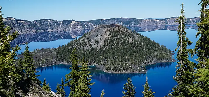
Medford, a city in the southern part of Oregon, is known for its cultural experiences and wineries. Named 'Medford' by David Loring, a civil engineer, the city offers outdoor activities for every season, be it hunting, camping, fishing, or snowboarding. The city is a blend between a bustling urban centre and a getaway close to nature. While outdoor enthusiasts can engage in lots of exciting activities here, art lovers are also in for a treat. Craterian Theater at The Collier Center for the Performing Arts offers musical shows, plays, and more. History buffs can visit Crater Rock Museum to witness gems and fossils. Rest assured that you'll have a full itinerary when you visit this city. To find out more, read on for the top things to do in Medford, Oregon.
Things To Do
12 Best Things To Do In Ashland, Oregon
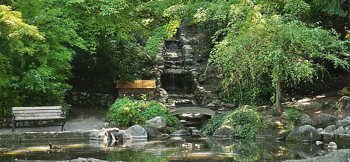
Ashland, Oregon, exudes a sense of laid backness and warmth. Perhaps it is the rich art scene here or the abundant natural spaces and sunshine that draws the crowds to Ashland. This city is often referred to as the cultural capital of Southern Oregon, which it certainly lives up to. After all, the city is home to the Oregon Shakespeare Festival, which has become an inseparable part of Ashland's culture. Getting from point to point in Ashland is also easy, just walking or biking can get you through town. With such conveniences and this list of some of the best things to do in Ashland, Oregon, head out to discover this city where beautiful natural spaces and deep cultural history intertwine.
Popular cities
Ashland (4)
Medford (4)
Vacation Rentals (10)
Airbnb (4)
Cabins (3)
Fishing Lodges (1)
Pet Friendly Vacation Rentals (1)
Vacation Rentals (1)
Hotels In (3)
Extended Stay Hotels ( 1)
Hotels With Airport Shuttle ( 1)
Where To Stay ( 1)
Things to do (2)
Things To Do (2)
Unique Stays (1)
Fishing Lodges (1)
Clear filter
Apply
Popular cities
Ashland (4)
Medford (4)
Good things are meant to be shared!
Close modal
Create an account to
Bookmark our articles
Give your favorite local expert tips a thumbs up
Receive great stories in your inbox
Follow writers and topics that you love
Log in with Google
Back to top