

The long and narrow park along the Shenandoah River Valley and Piedmont, Virginia’s rolling hills encompasses almost 80,000 acres (32,375 hectares) of protected wilderness and forests within its 196,000 acres (79,318 hectares). Paralleling the Appalachian Trail, the park displays amazing vistas of forests, valleys, wildlife, plant life, and changing weather throughout the year.
Farmland to national park history

Formerly used as farmland, remnants of old farms can still be found throughout the park. The last “original” resident, Annie Lee Bradley Shenk, died in 1979 at the age of 92 on her family’s homestead; the government agreement when the park was established in 1935 included a policy that permitted elderly and disabled to remain with life tenancy.
The Commonwealth of Virginia slowly acquired the land through eminent domain and turned it over to the US government provided the area would be designated as a national park. The remaining areas were purchased from landowners, who were then required to vacate their properties. Some entire communities were relocated with the development of the park.
Built almost entirely by members of the Civilian Conservation Corp, a government jobs program during the Great Depression, the park includes many structures now listed in the National Register of Historic Places including a statue in recognition of this program, Iron Mike.
The original facilities were designed with segregation in mind, a practice still prominent in Virginia in the early 1930s. Skyland Resort, Panorama Resort, and Swift Run Gap were solely for white people. As the park developed, the Lewis Mountain area development became the “African American” area of the park; it was substantially inferior to other park developments. By the early 1940s, the US Interior Department was increasingly striving to eliminate segregation from all park areas. The Pinnacles picnic area became the first integrated site in the park. During World War II much of the park closed. When it reopened following the war, integration was the norm and the park has remained integrated since.
The Skyline Drive

Make driving fun and relaxing. The Skyline Drive is designed to be just that – fun and relaxing. Roll down your windows, smell the fresh mountain air, feel the breeze, and experience the sights and sounds of this amazing national park as you drive along the crest of the Blue Ridge Mountains. The speed limit is only 35 miles per hour (56 kph) so drivers slowly meander through amazing scenic mountains and valleys.
The drive is the only public road in the park along the crest of the mountains. Totaling about 105 miles (169 km) north to south, a full length drive will take 3-4 hours depending on how often you stop and other vehicles on the road. If you have the time, it is well worth a drive in both directions.
Four main entrance points exist along the route: Front Royal near the junction of Routes 66 and 340, Thornton Gap at Route 211, Swift Run Gap at Route 33, and Rockfish Gap at the junction of Routes 64 and 250. Each entrance is about an hour from the next exit. Mile markers, located on the west side of the road, help guests locate points of interest as they drive through the park. Park maps and guides refer to these markers for highlights and activities. The 0.0 milepost is the Front Royal entrance (north) and continue to the southern end of the drive (milepost 105). Big Meadows, located near the center of the park at milepost 51 is the largest developed area in the park.
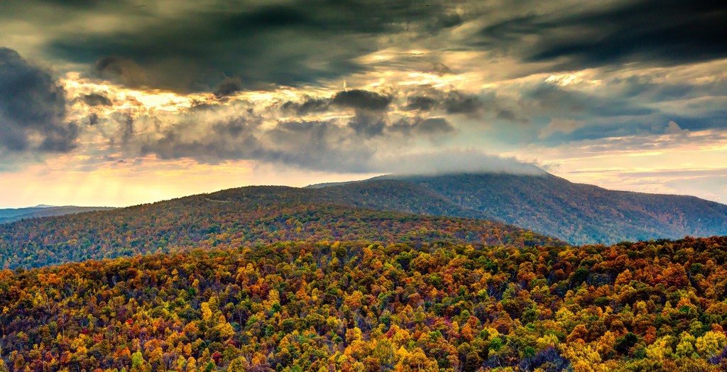
There are 75 overlooks providing spectacular views of the Shenandoah Valley to the west or Piedmont to the east. Wildflowers bloom abundantly all year with trillium in the early spring, colorful azaleas in June, and cardinal flowers, black-eyed susans, and goldenrods providing color into the fall months.
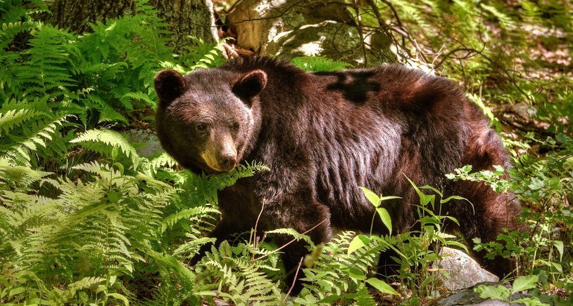
Wildlife is abundant in the Shenandoah National Park. Because these animals freely roam the park, watch carefully for animals that may dart across the road at any time. Remember it is unlawful to feed the animals in the park. You may enjoy a close-up look from within your vehicle, but you may want to roll the windows up. Deer, especially white-tailed, black bears, wild turkeys, and other woodland animals make their home in the park year round.
NOTE: If you are driving in an RV or similar vehicle you will need to shift into lower gears. The maximum clearance is 12’8" (3.8 m) at Mary’s Rock Tunnel (located just south of the Thornton Gap entrance). A driving map of Skyline Drive is available online (see the link below).
Hiking and camping
Almost 500 miles (805 km) of trails, ranging from easy to challenging, are designated within the park. Old Rag Mountain is undoubtedly one of the most popular. This trail offers breathtaking views of the valleys below, especially with fall colors, as well as a challenging rock scramble over loose rocks.
Horseback riding and trail cycling are available on some designated trails. Rangers provide guided hikes in the park for those who want more information on the history and geology of the park.
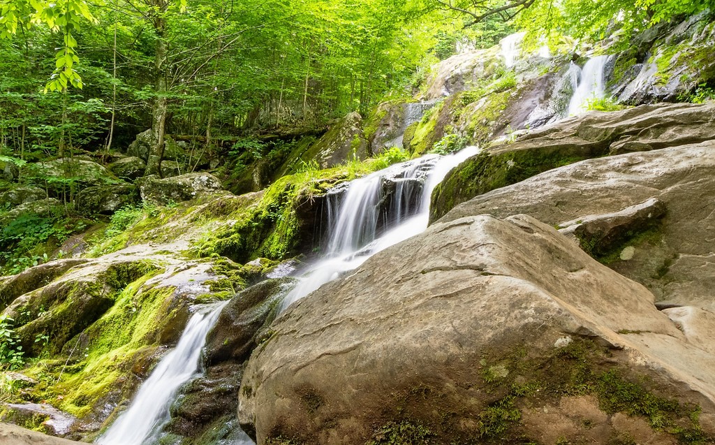
Many waterfalls are scattered throughout the park as well, especially in the springtime as the winter snows melt. The tallest waterfall is on a 6.5 mile (10 km) round trip hike. Known as Overall Run, just south of Hogback Overlook at mile 21, this waterfall tends to dry up by late spring. The Dark Hollow Falls waterfall is only a 1.4 mile (4 km) hike and closest to the Skyline Drive at mile 50.5; for this reason, it is the most popular waterfall in the park. Pets are not allowed on this trail.
My favorite trail is the Stony Man Trail because of the spectacular scenery. It ends at a cliff overlooking the Shenandoah Valley, which, in the fall, is overflowing with amazing color. It makes a great spot to watch the sunset! Pets and horses are not allowed on this trail. Bring a flashlight for the hike back if you are going at sunset.
Streams and rivers are popular for native brook trout, an attraction to fly fishermen.
Camping, including back country camping, is permitted in the park. Backcountry campers must follow a “Leave No Trace” policy, which includes burying excrement and no campfires. Food must be suspended in “bear bags” or secured in park-approved containers to prevent unintentionally feeding the bears. Venomous snakes are also scattered throughout the park, so hikers and campers must be vigilant at all times.
Birds love the valley and forests
Birdwatching is a popular activity within the park boundaries. The quiet valleys and dense forests create the perfect habitat for migrating and resident fowl.
More than 190 species of birds can be found in the park, the most abundant of which are warblers.
The biggest variety of birds can be found in the Big Meadows area. Year-round bird residents include Tufted Titmice, Red-tailed Hawks, Carolina Chickadees, Wild Turkeys, and Barred Owls.
Shenandoah is also an essential habitat for neotropical migratory birds such as the Ovenbird, cardinals, and grosbeaks. The deciduous trees provide essential nesting and resting opportunities for these birds. Bring your binoculars for the best viewing.
Explore the park with earthcaching
Shenandoah National Park has developed an earthcaching program to help visitors learn and explore the park using GPS units. You will also need the printout of NPS earthcaching guide and a pen/pencil.
There are no physical caches, rather natural features and wonders provide the treasures. All caches are along marked trails. Participants can chose to do as few or as many caching adventures as they choose.
You do need to set up a membership account before participating, but is free to do so online at the geocaching website below.
Dogs are welcome in this national park

Shenandoah is one of a few national parks that permit dogs on the trails with a leash. It is highly recommended that you evaluate your pet’s ability to explore the terrain safely and be prepared for emergencies! You must follow the park regulations to protect you, your pet, and the wildlife. Pets are allowed on most of the 500 miles (805 km) of trails in the park, in campgrounds, and in pet-friendly lodging. Pets are not permitted on Ranger Programs.
Words cannot describe the amazing vistas
Personally, I think the best time to visit the park is in the fall when the leaves are changing colors. The spectacular color collage created by crisp air and brilliant sunshine is truly inspiring and amazing.
History
Get Trip101 in your inbox
Unsubscribe in one click. See our Privacy Policy for more information on how we use your data